What Is, Apacheria?
Apacheria is a term the Spanish first used when they encountered the natives that they began to identify as Apaches. Apache comes from the Zuni word, "Apachu," and I believe, before that, "Apituh" by another of the "tribes" of the Puebloan societies. Apacheria is a vast area where the peoples the Spanish, then Mexicans, and ultimately, Americans, labeled as "Apaches." These groups include: Arizona "Apaches," such as Cibicue, Pinal, San Carlos, Tonto and White Mountain Apaches. These groups are generally called "Western Apaches," as opposed to "Eastern Apaches."
Regardless of whether Western or Eastern, whether Arizonan or New Mexican, the groups which were labeled as Apaches were generally seen as more belligerent and aggressive than Puebloan groups. As the Navajo are the other "part" of the Athapaskan or Na Diné peoples, the Navajos were also aggressive and war like when they entered the Southwest and became lodged in Arizona and New Mexico. Athapaskan is a cultural term, but I believe it would be most accurate to say that the language Apache or Navajo come from are Athapaskan in nature.
If I were to say which state -- Arizona or New Mexico -- contained more Apacheria, I'd have to say they're both about the same. New Mexico is the fifth largest state of the Union; Arizona sixth. In the northern part of New Mexico, were the Jicarilla Apache. Farther east were the Mescalero.
In even earlier times, the Lipan and Kiowa-Apache groups were located in the far northeast, above what is now I-40, and east of I-25. They were often pushed from the western Texas/Oklahoma areas by the Commanche and Utes, who were of the Uto-Aztecan language group, into New Mexico.
There are Chiricahua Apaches in New Mexico. They are the Eastern Chiricahua, in the Warm Springs, or Chihenne N'de Apache, located near Ojo Caliente, along the Rio Alamosa, along Cañada Alamosa. This area is northeast of Truth or Consequences. The Warm Springs were the band which were led by men such as Largo, Loco, Nana, and Victorio. Lozen, the alleged "Apache woman warrior," was also a Warm Springs Apache.
Farther west of Ojo Caliente are the Giléno, Coppermine, Gila, Mogollon, Bedonkohe, or Mimbres Apaches, who are located in the area south of I-40, west of I-25, north of the Mexican-New Mexican-Arizonan line. This group includes the famous Bedonkohes, Mahko, Geronimo, Chihauhua, Jolsany, or Jolsanny, or Ulzana, and, Mangas Coloradas. The Bedonkohe's according to experts such as Edwin Sweeney and David Roberts fall under the Chokonen family (band) of Eastern Chiricahhuas.
These groups appear to have been mostly located in what has become Grant and Catron Counties, and ranged certainly over Hidalgo and Luna Counties, as well as Doña Ana County, in New Mexico. The Arizona-New Mexico line seems to have been a natural division of Eastern Chiricahuas of these groups, and the Western Chiricahuas, who lived in the Chiricahua and Dragoon Mountains. Of course, Cochise was the leader of the Western Chiricahuas.
All of this was "Apacheria."
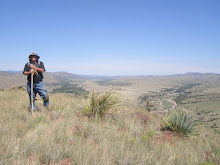
To give an idea of the vastness of "Apacheria", I was recently atop the Signal Peak Fire Tower. As far as I looked, in a vast oval, that included the Animas, Mogollons, Pinos Altos, Burros, San Franciscos, Blues, Canyon Creek, Peloncillos, Black Range, Mimbres, Big and Small Hatchets, Flying W's, Victorio's, Grandmothers, Cooke's Range, Floridas, Tres Hermanas ... all of these mountains ... were in some way, visible from Signal Peak ... an area of 4500 square miles, the Fire Tower Watcher told us.
And all of that area was just the area ranged by the Mimbres, Coppermines, Mogollon, Bedonkohe and Warm Springs Apaches. And even there, their range went on beyond ... only by traveling all across the southwestern corner of New Mexico can one understand just how vast this area is.
Finally, south of the Border, in Chihuahua and Sonora States, were the N'de N'ai, Nednai ... the "wildest Apaches among the Apaches." They were small in number, and most often aligned with the Western Chiricahua (Cochise's Group, and later, the group led by Geronimo and Naiche). Naiche was the second son of Cochise. His first son, Taza, died in Washington, D.C., while on a tour of the nation's capital. He was taken there to meet the President, in an effort to quell the violence in Arizona.
Apacheria was vast, and the Bedonkohe Apache of Grant and Catron Counties, could negotiate their way all the way into Mexico, all the way into Arizona, all the way east to the Rio Grande, all the way north, to Reserve and Zuni Salt Lake, Quemado, Pie Town, Datil, Socorro.
This is a huge area for any peoples who never numbered, probably, 10,000 for all Eastern & Western Chiricahua Apache (not including Jicarilla and Mescalero)!
Such was the range of the Apaches.
Regardless of whether Western or Eastern, whether Arizonan or New Mexican, the groups which were labeled as Apaches were generally seen as more belligerent and aggressive than Puebloan groups. As the Navajo are the other "part" of the Athapaskan or Na Diné peoples, the Navajos were also aggressive and war like when they entered the Southwest and became lodged in Arizona and New Mexico. Athapaskan is a cultural term, but I believe it would be most accurate to say that the language Apache or Navajo come from are Athapaskan in nature.
If I were to say which state -- Arizona or New Mexico -- contained more Apacheria, I'd have to say they're both about the same. New Mexico is the fifth largest state of the Union; Arizona sixth. In the northern part of New Mexico, were the Jicarilla Apache. Farther east were the Mescalero.
In even earlier times, the Lipan and Kiowa-Apache groups were located in the far northeast, above what is now I-40, and east of I-25. They were often pushed from the western Texas/Oklahoma areas by the Commanche and Utes, who were of the Uto-Aztecan language group, into New Mexico.
There are Chiricahua Apaches in New Mexico. They are the Eastern Chiricahua, in the Warm Springs, or Chihenne N'de Apache, located near Ojo Caliente, along the Rio Alamosa, along Cañada Alamosa. This area is northeast of Truth or Consequences. The Warm Springs were the band which were led by men such as Largo, Loco, Nana, and Victorio. Lozen, the alleged "Apache woman warrior," was also a Warm Springs Apache.
Farther west of Ojo Caliente are the Giléno, Coppermine, Gila, Mogollon, Bedonkohe, or Mimbres Apaches, who are located in the area south of I-40, west of I-25, north of the Mexican-New Mexican-Arizonan line. This group includes the famous Bedonkohes, Mahko, Geronimo, Chihauhua, Jolsany, or Jolsanny, or Ulzana, and, Mangas Coloradas. The Bedonkohe's according to experts such as Edwin Sweeney and David Roberts fall under the Chokonen family (band) of Eastern Chiricahhuas.
These groups appear to have been mostly located in what has become Grant and Catron Counties, and ranged certainly over Hidalgo and Luna Counties, as well as Doña Ana County, in New Mexico. The Arizona-New Mexico line seems to have been a natural division of Eastern Chiricahuas of these groups, and the Western Chiricahuas, who lived in the Chiricahua and Dragoon Mountains. Of course, Cochise was the leader of the Western Chiricahuas.
All of this was "Apacheria."
To give an idea of the vastness of "Apacheria", I was recently atop the Signal Peak Fire Tower. As far as I looked, in a vast oval, that included the Animas, Mogollons, Pinos Altos, Burros, San Franciscos, Blues, Canyon Creek, Peloncillos, Black Range, Mimbres, Big and Small Hatchets, Flying W's, Victorio's, Grandmothers, Cooke's Range, Floridas, Tres Hermanas ... all of these mountains ... were in some way, visible from Signal Peak ... an area of 4500 square miles, the Fire Tower Watcher told us.
And all of that area was just the area ranged by the Mimbres, Coppermines, Mogollon, Bedonkohe and Warm Springs Apaches. And even there, their range went on beyond ... only by traveling all across the southwestern corner of New Mexico can one understand just how vast this area is.
Finally, south of the Border, in Chihuahua and Sonora States, were the N'de N'ai, Nednai ... the "wildest Apaches among the Apaches." They were small in number, and most often aligned with the Western Chiricahua (Cochise's Group, and later, the group led by Geronimo and Naiche). Naiche was the second son of Cochise. His first son, Taza, died in Washington, D.C., while on a tour of the nation's capital. He was taken there to meet the President, in an effort to quell the violence in Arizona.
Apacheria was vast, and the Bedonkohe Apache of Grant and Catron Counties, could negotiate their way all the way into Mexico, all the way into Arizona, all the way east to the Rio Grande, all the way north, to Reserve and Zuni Salt Lake, Quemado, Pie Town, Datil, Socorro.
This is a huge area for any peoples who never numbered, probably, 10,000 for all Eastern & Western Chiricahua Apache (not including Jicarilla and Mescalero)!
Such was the range of the Apaches.
posted by skyminder at
4:04 PM
![]()

1 Comments:
jerry....
glad to see your thoughts and work with appacheria on the web.... i'm following your blog!
Post a Comment
Subscribe to Post Comments [Atom]
<< Home