Experiencing Apache Country & A Find
Hello! I've got several friends out there who have asked to go hike with me.
I want to send some photos in the next day or two that show a typical hike.
The hike is LS Mesa.
The hike, begins, rather on LS Mesa. LS Mesa is a long mesa, typical of Apacheria here in NM, which runs 10 to 15 miles, east to west. It juts out over Bear Creek, which begins in Pinos Altos, and runs all the way to the Gila River, literally dumping into the Gila River near the town of Gila, NM.
There's a Gila River Festival, this weekend, @ Gila. There's also Ft. Bayard Days, which is where I'll be today (Saturday). I'm also being interviewed for the Fourth Time on KVOI, "Voices Of The West," Tucson. There's also a lot going on in Silver City, NM, in conjunction more with The Gila River Festival than Ft. Bayard Days. The latter is locally funded and produced. So is the former, but the former seems far more sophisticated in it's approach. At least to me.
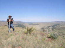
The hike I took Wednesday was off the LS Mesa dirt road, and the start point is about 3 miles off that road, on forest service roads. I have wanted to do this hike for months. Sometimes the LS Mesa Road is very bad during rainy season, but not Wednesday. I went from ridge line to ridge line, much as the Apaches did. I reached a high point, about 1-2 miles distant from where I began. While up there, I could see a vast area that went off, mostly, to the south, west, and north.
The view is extraordinary, especially this time of year, or in the Winter. This time of year, when the rains have turned everything lovely green for a few months, there are very few things as beautiful as a those off LS Mesa -- lush green mesa, or series of mesas, with large mountains as backdrops, or, in the winter, the same distant mountains covered in snow. The mountains are Los Diablos, a basically unknown mountain range, and the Mogollons, as well as the Big Burros.
New Mexico has many, many mountain chains, or ranges, most no more than 20 - 30 miles in length v. the massive Rockies in Colorado, Wyoming, Wasatch, Unitas, Big Horn, etc., in Utah or Montana. The scene on LS Mesa is generally open range cattle grazing, after the rains.
I hike there because Mangas Coloradas, the great Bedonkohe warrior, chieftan, had his home rancheria in this area. Supposedly, he has one of several "strongholds" in this area, and I may have found one worth investigating. When I was at the highest point on my hike, I scanned the country, and saw a series of rock formations that I call "clamshells," which more or less were oriented not for the late summer sun, but the winter sun. These "clamshells" open to the winter sun, and are typically superb places to "find" items of interest.
Sure enough, from a mile away, I saw a long series of clamshells facing towards the best winter sun orientation. I made a series of notes on how to cut across country and get to the jumping off point ... literally, to begin the descent into a cañon where they were located. As I walked, I adjusted my route, and eventually, always watching my front, searching for a series of rocks, I found the spot.
I took pictures of the clam shell overhangs, under which were some rock walls that had been set up under the overhang, but none with mortar. The ancient ones, and probably the Apache, arranged rock walls for granaries, or structures, caches, and "mortared" them with mud adobe, or more precisely, mud. As I was leaving, I saw another layer of rocky outcropping, and after deciding I hadn't searched there, I climbed up and found, lo and behold, a grannary. Here are a few photos.
The experiences I've gained over the years, always, always, searching the surrounding area, allowed me to make an educated guess, as to where these objects of interest might be. And, I know now, based on the extent of length and height, that this series of rocks, which go about 1/8 mile, will require many searches, since they are layered like a cake, each one worth evaluating.
Coming out of the cañon was a bear. The steepness of the slope, along with all the cacti and brush (very dense), made climbing up the 200 or so feet of cañon so bad that I wondered if I'd get out of there. I hadn't eaten properly, and I also had to husband my water. I always try and arrive @ my truck with a full quart of water still left, in that there are always things (negative) that can happen, which will demand I NOT drink every drop of my water until I actually get IN my truck, it cranks, I can drive out of the more remote roads to the first major road, where, if I had trouble, I'd be able to hike and probably catch a ride.
These clam shell sites are going anywhere. I can view them better by a separate hike from the east side of the cañon (as the sites are south facing, that means they're on the north side of the cañon). Coming in from the southeast, I can view all of them with binoculars, and determine for certain if any more sites are visible. I think it's likely there are some dwellings in this area, but it makes more sense now to view them from the south and east side of the cañon first.
The Stronghold rock outcropping offers a tremendous view of the entire country that would have belonged to the Coppermine, or Gila Apaches, of Mangas Coloradas. It will be the hikes to the Stronghold, which will motivate me to return here. So, here are some photos of that hike. It is a true, "Hiking Apacheria" hike.
I want to send some photos in the next day or two that show a typical hike.
The hike is LS Mesa.
The hike, begins, rather on LS Mesa. LS Mesa is a long mesa, typical of Apacheria here in NM, which runs 10 to 15 miles, east to west. It juts out over Bear Creek, which begins in Pinos Altos, and runs all the way to the Gila River, literally dumping into the Gila River near the town of Gila, NM.
There's a Gila River Festival, this weekend, @ Gila. There's also Ft. Bayard Days, which is where I'll be today (Saturday). I'm also being interviewed for the Fourth Time on KVOI, "Voices Of The West," Tucson. There's also a lot going on in Silver City, NM, in conjunction more with The Gila River Festival than Ft. Bayard Days. The latter is locally funded and produced. So is the former, but the former seems far more sophisticated in it's approach. At least to me.
The hike I took Wednesday was off the LS Mesa dirt road, and the start point is about 3 miles off that road, on forest service roads. I have wanted to do this hike for months. Sometimes the LS Mesa Road is very bad during rainy season, but not Wednesday. I went from ridge line to ridge line, much as the Apaches did. I reached a high point, about 1-2 miles distant from where I began. While up there, I could see a vast area that went off, mostly, to the south, west, and north.
The view is extraordinary, especially this time of year, or in the Winter. This time of year, when the rains have turned everything lovely green for a few months, there are very few things as beautiful as a those off LS Mesa -- lush green mesa, or series of mesas, with large mountains as backdrops, or, in the winter, the same distant mountains covered in snow. The mountains are Los Diablos, a basically unknown mountain range, and the Mogollons, as well as the Big Burros.
New Mexico has many, many mountain chains, or ranges, most no more than 20 - 30 miles in length v. the massive Rockies in Colorado, Wyoming, Wasatch, Unitas, Big Horn, etc., in Utah or Montana. The scene on LS Mesa is generally open range cattle grazing, after the rains.
I hike there because Mangas Coloradas, the great Bedonkohe warrior, chieftan, had his home rancheria in this area. Supposedly, he has one of several "strongholds" in this area, and I may have found one worth investigating. When I was at the highest point on my hike, I scanned the country, and saw a series of rock formations that I call "clamshells," which more or less were oriented not for the late summer sun, but the winter sun. These "clamshells" open to the winter sun, and are typically superb places to "find" items of interest.
Sure enough, from a mile away, I saw a long series of clamshells facing towards the best winter sun orientation. I made a series of notes on how to cut across country and get to the jumping off point ... literally, to begin the descent into a cañon where they were located. As I walked, I adjusted my route, and eventually, always watching my front, searching for a series of rocks, I found the spot.
I took pictures of the clam shell overhangs, under which were some rock walls that had been set up under the overhang, but none with mortar. The ancient ones, and probably the Apache, arranged rock walls for granaries, or structures, caches, and "mortared" them with mud adobe, or more precisely, mud. As I was leaving, I saw another layer of rocky outcropping, and after deciding I hadn't searched there, I climbed up and found, lo and behold, a grannary. Here are a few photos.
The experiences I've gained over the years, always, always, searching the surrounding area, allowed me to make an educated guess, as to where these objects of interest might be. And, I know now, based on the extent of length and height, that this series of rocks, which go about 1/8 mile, will require many searches, since they are layered like a cake, each one worth evaluating.
Coming out of the cañon was a bear. The steepness of the slope, along with all the cacti and brush (very dense), made climbing up the 200 or so feet of cañon so bad that I wondered if I'd get out of there. I hadn't eaten properly, and I also had to husband my water. I always try and arrive @ my truck with a full quart of water still left, in that there are always things (negative) that can happen, which will demand I NOT drink every drop of my water until I actually get IN my truck, it cranks, I can drive out of the more remote roads to the first major road, where, if I had trouble, I'd be able to hike and probably catch a ride.
These clam shell sites are going anywhere. I can view them better by a separate hike from the east side of the cañon (as the sites are south facing, that means they're on the north side of the cañon). Coming in from the southeast, I can view all of them with binoculars, and determine for certain if any more sites are visible. I think it's likely there are some dwellings in this area, but it makes more sense now to view them from the south and east side of the cañon first.
The Stronghold rock outcropping offers a tremendous view of the entire country that would have belonged to the Coppermine, or Gila Apaches, of Mangas Coloradas. It will be the hikes to the Stronghold, which will motivate me to return here. So, here are some photos of that hike. It is a true, "Hiking Apacheria" hike.
posted by skyminder at
6:27 AM
![]()

0 Comments:
Post a Comment
Subscribe to Post Comments [Atom]
<< Home