Cañon de los Embudos - 2011


Recently, with the help of some fantastic Mexican hosts, I was able to return to Cañon de los Embudos, where General Crook & Geronimo met to discuss the latter's surrender in 1886. It was with some serious forethought & careful review of the security situation in Mexico that we went. The guy who has been filming a documentary for over six years (four with me in the scheme of things) went with me. We had assurances from our Mexican hosts that we would be safe there, @ their place, that we were able to visit Puerto Palomas; Ascension; Janos; one of the colonia des Mennoites; Montaverde. We also visited Cañon de los Embudos.
To visit Cañon de los Embudos, we had to separate out their earlier visits to "El Embudos" which are on the eastern side of the Sierra los Embudos & Sierra de San Luis. The relative height of the former are around 2200 meters (over 6600 feet). There are many mountain ranges that move off & run from north to south, some of which are also in the U.S., as well as other ranges that run more northeast, southwest.
Sierra los Embudos is in that posture.
It's necessary to enter & drive through both Chihuahua & Sonora States.
With only a passport needed for a short visit, & as we had no vehicle to register with Mexican auto insurance, we rode w/our Mexican hosts w/a sense of greater safety.
We encountered military check points @ several locations.
The check points were manned by serious but young soldiers. All carried assault rifles & there were several machine guns present @ each check point.
It looked like a squad of soldiers @ each check point.
It is vital that anyone expecting to visit Cañon de los Embudos w/out any knowledge of where the place is located, to get lost.
There are many mesas & potential contenders for "THE Cañon de los Embudos." I recalled the directions well
enough to get us there again.
Even so, w/more information it's now clear to me that there are multiple locations for rancherias.
Use of Jay Van Orden's Monograph (published by Arizona Historical Society) on C. S. Fly's famous photo series of these momentous talks is essential to even coming close to finding the area where the surrender took place.
There are several interpretations as to where the rancheria in Fly's photos are located.
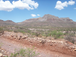
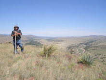
Here are a few photos from this visit.
In talking with Jay Van Orden we feel confident that while we weren't precisely on the site of the surrender conference between General Crook & Geronimo, Naiche, Chihuahua, Alchesay, Nana (Na-NAY) and Olsanny (Ulzana), we were close.
Again: do not attempt this trip alone. Do not attempt this trip if you speak no Spanish. Had we not had fluent Spanish speakers w/us, we likely would NOT have had the good fortune to find this place.
Do not drive after dark.
Do not assume you will be able to travel about at any time without encountering danger.
Sadly, Mexico has been transformed by the violence.
ON THE OTHER HAND, our hosts were wonderful & imparted enormous new information. We also learned about sotol, which is the indigenous drink of Chihuahua. Taken from the desert spoon yucca, it's not mescal nor is it tequila.
It's the "state drink" in terms of naturally harvested products.
While sotol is more expensive than tequila or mescal, it's supposed to be quite the drink. It can be mixed w/other modifiers.
We hope very much to revisit our hosts soon & expand the knowledge we Americano & Mexican Apache students of history love.
Photos: Top Left to Right; Left to Right:
General area of surrender conferences, Cañon de los Embudos;
Scene looking south into Mexico, EAST of Cañon de los Embudos, on Highway 2;
Sierra los Embudos & key landmark of surrender area;
General area of conference surrender discussions;
Looking south into Mexico, from road into Cañon de los Embudos;
the northeastern extent of Cañon de los Embudos;
Military Checkpoint.
Labels: Apache; Ascension; Agua Prieta, NM;


0 Comments:
Post a Comment
Subscribe to Post Comments [Atom]
<< Home