Back From the Wounded ...


As some know, I was pretty badly injured on 21 December @ a place named Providence Cone. It's near Akela, New Mexico, on I-10. If you're driving east, towards Las Cruces, it would be on your right. If headed west, it would be on your left. The "Cone" is roughly five miles south of I-10 and about 25 east of Deming. It's a very interesting rock, and the more I learn about it, the more there is to find/learn.
While I cannot state for certain, my guess is that there are a # of features there that would tell me the place had water, perhaps in abundance, during the rainy season, and definitely after snow. There were a # of small seeps and even a few springs coming from the rocky north side of the "Cone." I've been there when there are as many as several dozen of these "leaks" from the rock. Most likely, the rain & snow melt fall on the surface of the peak, and then it percolates down through the granular, rough rock, and comes out and then runs down the sides of the "mountain." If one is up on top, there are views that are 360º and show how valuable locating there would be.
This time, I explored even more, although I was limited in my ability to climb or walk much. I have a large, firm fiberglass and felt "boot" that provides me with a rigid frame within which I can walk. I have had some sciatic pain associated with the walking, since I'm unbalanced. I added some heel lifts, so I can walk with a little less awkwardness.
The article I wrote on the injury, "Trauma On The Trail," is available on www.desertexposure.com/apacheria, and then the "Trauma" addition. I want to include a few photos, in color, for those who haven't seen this place, and the magnificent views it affords. The distant Florida Mountains, of course, are some of the most favorite hiking locations in my "experience." I think the solitude and Apache history of those mountains makes them very, very special. I must have hiked there 50 times since 2003. I believe that with all the snow we've had in SW NM, we will have an extraordinary wildflower year.
Lastly, I've heard that the Chihene N'de Apaches are coming to T or C or Ft. Bayard, in March, and I've offered to take them to a few special places, if they would like to go. Where would be dependent on what their hiking abilities would be, as well as mine. There are a few that are extraordinary, but they might now be out of my reach, too.
Some photos.
Welcome to new readers and thanks for returning, to old readers.
The First Photo on the top left is what I call, "crack rock art." It's a clear petroglyph, and it represents, I believe, a native American with ear ornaments. There is every indication that visitors from Mexico, or Neuva Vizcaya, now, Chihuahua State, came north from the Casas Grande/Paquime Region. Many archaeologists consider the people of Paquime Mogollon type people;
The First Photo on the top right is what I've called "Kokopeli." Mind you, I see an abstract version of Kokopeli, but I must say, when I first saw it three years ago, I was stunned at the precision of the petroglyph, and the size (roughly 3-4 feet in height). It is very easy to not even SEE this work of art. I found it three years ago on the single day hike my friend Pete Crum & I took to the place. We'd neither of us been there before.
I returned on 15 or 16 December, to try and find it. I didn't. I went home, looked at my old photos, and got oriented to the background view, and went straight to it on the 21st of December;
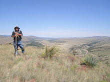
The Second Photo on the left is of the Floridas from the top of Providence Cone. The Floridas are roughly 20 miles, straight line, from the Cone, and there was water along the way, I'm certain, by archaeological signs left even today;
The Second Photo on the right is of the Floridas around 10 December,after the first major snow fall. The water coming down the arroyo was running steadily, and at that, roughly 1.5 - 2.0 miles from the snow line in the Floridas. I believe where this photo was taken was a very special place for the Apaches, because there was water there in the right seasons;
The last photo on the left is the "Fall Zone, Crawl Zone" of Providence Cone. The Fall Zone is where I fell. I;m not exactly sure, but I think I was pretty near the top as this photo is taken. The "actual" top of the peak is much higher. The photo makes it appear lower than it is. The Crawl Zone, of course, is the distance down the rock and onto the flats that I had to crawl. Again, see my article for how I did that.
I am working on the second part of that event, because there were many lessons there, too.
posted by skyminder at
8:56 PM
0 Comments
![]()