Sunday, September 27, 2009

Chiricahuas, Ed Sweeney & Fred Lafferty


Friday, September 25, several of us from Silver City, drove over to the Chiricahuas south of Rodeo, New Mexico, to meet with #1 writer of Apache history, Edwin Sweeney, to revisit a battle site fought over 140 years ago. The story, written years ago by Ed Sweeney, in his book, "Cochise: Chiricahua Apache Chief," was an incident in the skirmishing and campaigning against Cochise's Chiricahua Apaches.

**The photo at top left is the leading writer on Apacheria -- Edwin Sweeney. He holds the "map drawing" a soldier of Col. Reuben Bernard's command made after the fight at the "rimrock mesa" skirmish.

The photo at right is Navy Commander Fred Lafferty, (Ret), great-grandson of Lt. John Lafferty, First Cavalry, who distinguished himself with bravery in the skirmish with Cochise's Apaches near where Camp Rucker was ultimately located.

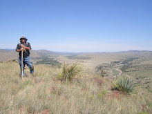
The photo at the left is of the rimrock mesa top (one of several "tops" that charging troopers would have encountered as they tried to make their way to the very flat top of the mesa where Cochise and his men were established.

The photo on the right is of the large hill mass to the north/northeast of the rimrock mesa where Cochise and his Apaches fought Col. Reuben Bernard's troopers of the First Cavalry.


The American commander of the troops chasing the Apaches was Col. Reuben Bernard, known in some circles as an aggressive "Indian fighter." Col. Bernard eventually was named a General at the conclusion of his military career.
A summary of the active military career Col. Bernard experienced is contained in a book, "One Hundred and Three Fights and Scrimmages: The Story of General Reuben F. Bernard," by Don Russell (reprint now available on Amazon.com), new/used; Stackpole Books, Mechanicsburg, PA.

Edwin Sweeney wrote an Introduction to the reprinted volume in 2003, and summarizes the fire fights (skirmishes) we'd call in current combat lingo.
The fire fight in October, 1869, saw Americans killed and wounded, and the same for the Apaches who fought from their mesa positions, fairly secure in rimrock based firing positions. And it was in that fire fight that the life of Lt. John Lafferty, cavalryman, was altered forever.

Lafferty was wounded, and suffered painful and debilitating effects from his wound for the rest of his life. He was also the great-granddfather of Fred Lafferty, local citizen and retired naval aviator careerist, who I met two years ago, as I interviewed him for an article about his great-grandfather, his father, and his own military career.


It was quite a trip to the Chiricahuas, south of Rodeo, south of Cave Creek.
The Chiricahuas are truly beautiful this time of year, and the grasses that grew there were lush and so different from the land directly east of the highway from I-10 to Douglas, AZ. Betty Lafferty said that one driving south, towards Douglas, would never know the beauty of the Chiricahuas we saw along the road to Rucker Cañon. She was right. A very beautiful country indeed. It's no wonder that the Chiricahua Apaches loved the country and it's clear why they would have fought so hard to retain these mountains and lowlands against the Americans.

The trip, I believe, gave Fred and his wife, Betty, some satisfaction in that they've been married over 50 years, and undoubtedly, have shared the story many times over those years. That Fred is descended from John Lafferty (who was finally brevetted as a Captain before he retired for medical reasons), is interesting in that this was a particularly well documented fire fight, as far as fire fights go in military history. Col. Bernard, of course, was required to report on his "scouts" which began and ended at Ft. Bowie. In the era, each scout or what we'd call, now, "patrol," had a requirement for the scout leader to report how far his unit had "marched," and, what the conditions were that they encountered before stopping for the night. Regular features of such patrols included what the condition of the route of march was; encounters with Apaches; casualties; the nature of water, grass and timber availability at each evening bivouac.

In the case of the "rocky mesa" fire fight in which Lt. Lafferty was so badly wounded, an enlisted man actually drew, on four sheets of paper, a drawing of the terrain of the fight, and then marked, with numbers, the significant places or important features that defined the fight itself. Because of that drawing, historians, such as Edwin Sweeney and myself, have been able to literally SEE where Lt. John Lafferty was wounded.

With the detail we had available to us, then, Edwin Sweeney was highly pleased to be able to take Fred Lafferty almost to the exact spot where his great-grandfather was wounded by an Apache. Lt. Lafferty, in today's realm of awards granted for heroic actions, would have surely been nominated for at least, a Silver Star (SS). Perhaps even a Distinguished Service Cross (DSC) for heroism.
The reason Lt. Lafferty was shot was because he'd exposed himseslf, and tried to recover the bodies of two dead soldiers, on that rocky slope. The concern, of course, was the fear that the bodies of the two dead men would be horribly mutilated, if they had to be left on the field of battle.

Because Lt. Lafferty was so badly wounded (a heavy duty rifle round shattered his right jaw), the bodies were actually left on the scene overnight.
Thus far, I've not found any specific mention of whether those bodies were mutilated during the night. Contrary to the nature of Plains Indians, the Apache were very frightened of being around, much less, touching dead bodies. To touch a dead body was a very dangerous thing for Apaches to do. The Apache were very superstitious of death. They would normally not enter a wickiup if a person had died in that wickiup, and had been dead for a period of time.

The Apache believed that "ghosts" of the dead roamed the earth, seeking solace, or, perhaps, if malevolent, lure the living into the world of the dead. If a person had died in a wickiup, and could not be touched, then the entire wickiup and body would be burned together. The name would not be spoken again. This is one reason why some names were forgotten of ancestors, by living Apaches. Perhaps in the days before Spanish, Mexicans and Americans began to encounter the Apaches, names of dead relatives really were forgotten, so that tracking lineage was difficult.

I'm forever grateful an enlisted man was so gifted in his ability to draw the battle scene, we were able to go to the spot where Lt. John Lafferty was so badly wounded, in October, 1869.
For me, as someone who was badly wounded in combat, I've always felt that wherever, in the world, a soldier dies, or is wounded ... that that spot (particularly where people have been killed in combat), is sacred.

Wherever it may be, wherever a person dies defending his or her way of life, that spot is sacred for me. Whether Nazi, Apache, Communist Viet Cong, or American GI invader, the sacrifice for the "cause" is most often made for at least a perceived worthiness of that cause. There may be some who are seriously deluded about the rightness of their causes, but people who sacrifice their lives do so with generally, good intentions.

Americans, in the end, had the luxury of returning to the site of the fight, the next day, to retrieve bodies left on the field. One has to wonder, though, how many Apaches were really killed in this fight? What did troopers do to their bodies? Were their bodies left to rot on that mesa? What did the Apaches do if they left the battle field, and returned to find decomposing brother Apaches among the rocks and cactic?


So far as the Apaches are concerned, we don't know their names, nor what kind of warriors they had been, before finding death there, in October 1869. Forever, the relatives of those dead Apaches would see their fate, as honored men, in doubt, if they had not been able to be cared for properly, as Apache custom dicates.
So, we Americans were lucky to be able to return to the sight of a fire fight that occurred 140 years ago, and show the descendant of John Lafferty, where his ancestor was badly wounded, fighting Apaches who were often like ghosts.

That's a clear connection between the war I fought in Vietnam, and the war Lafferty, et al, fought with the Apaches, in the Chiricahua Mountains. The elusiveness of the "enemy," so far as the Apaches, and Viet Cong were concerned, was bothersome. Why won't the bastards stand and fight? What a bunch of cowards! What's the matter with them! We never find any bodies. Or, they disappear like ghosts.

And so they did ... Apaches and Viet Cong. Did we not do the same thing in our Revolution?

Of course, we did. And were proud of it, and turned the tide against the finest professional military in the world, at the time. Upstart colonials beat the best the British Crown could send our way. And so, I suspect, many a soldier in the U.S. Cavalry, during the Indian wars, could recall how a great-great-grandfather had told them about fighting the British, and how they had tweaked the Brits with their ambush and run style of warfare. It drove the British nuts, and it drove American soldiers nuts, when it was the Apaches turning the screw on us.

So, too, now, in Afghanistan and Iraq.

The wheel of time and war always turn. Sooner or later, those on top will find themselves on the bottom. It's simply inevitable. By now, we should understand that all Empires have cycles, and that modern America, fighting in Iraq and Afghanistan, needs to remember what it was like to fight hard for your own land. Say what you might about the Apaches: who could ever blame them for fighting for these lands?

Wednesday, September 23, 2009

3 examples of field positions


These are four different firing "positions" I've found just in the Florida Mountains, east of Deming, NM. They are located near a known "battle site." They are interesting in that most are faced east, north or south, but one I found, was faced west, and would have covered what I think was an escape route over the top of the range.

For what it is worth, the Floridas are one of my favorite hiking places. I've mostly hiked on the east side, because there's not much development on that side. On the west side, development is all around, and it is demoralizing to me to hike all day and see a city spreading out beyond me, slowly creeping farther up the mountains themseves.

I really like the isolation I find on the East side. It is an illusion, of course, but nonetheless, I can attest to the statement that in over 50 hikes in the Floridas, I've NEVER run into a single hiker hiking where I am. I have SEEN a few hikers from a distance, and on one occasion, I ran into a man who was hiking in a cañon that is the only place in the entire range set up for hiking.

The photo above, left, actually has running water after rains or during snow melt. There is a pipe (heavy plastic) that is inserted into the spring that the water emanates from, and which runs down to tanks, far below and to the east. I've seen water glistening off the rocks there, and it is, in fact, one of the reasons the fighting positions are located near this place. It was, a place where water flowed freely until the 1870s, when ranchers began to tank it up.

The pointed rock in one photo is what I call a "marker" or "pointer" rock. I believe that rock points to the lowest part of the Floridas. I believe that area is where Apaches would be able to take women and children on foot, or horse, over from the east to west side, and the firing positions on the ridge line I've identified are focused on luring anyone trying to chase the Apaches into a fire fight there.

The photo that has a rock bench and "mortar in bedrock holes" in it is on a now dry arroyo. I've seen water in it once, but I suspect 125 years ago, and certainly 300 years ago, when the Apache began moving around in the Floridas, there was water more often.

The holes, I should note, retain water, in the summer and snow melt of winter & spring. I've found some deep enough to contain 2 - 3 liters of water each. I believe that Apaches may have used them, also, for caches, simply by mudding up the top, and then laying rocks over them to conceal them. I've found one or two such holes like that. While these holes might allow five or six women to work on grinding grains or berries (none show those stains, however), they also would be in prime positions to collect water when the rains come. Placed in known drainage paths on the rocks, the Apache could have ground these out from natural holes in the rock, making them wider and deeper. In this way, if being chased by enemies in the summer months, when the summer rains come, the Apaches might know there would be water in such locations. They would either drink the water up themselves, or, allow their horses to consume the water ... preventing chasers from doing so.

Labels:

Sunday, September 20, 2009

Ft. Bayard Days & Apacheria


Ft. Bayard Days was advertised as a Day when Buffalo Soldiers and Warm Springs Apaches would "get together," for the first time, and share. There was initially a promise of "healing and sharing." Some of the Apaches @ the gathering were essentially "open" to this prospect, but in fact, other Apaches that I heard and spoke with were not at all up for such a discussion.
In my own experience with the Vietnam War, I can say that healing in my case, and in many others cases, came only after years of dealing with the horrors of war. In actuality, we do not know much about what happened to the Apaches if they were captured, by Buffalo Soldiers. I know that when some Warm Springs Apaches and others, were captured, I believe, after the 1873 "break out" from San Carlos, they were marched to Ft. Apache roughly and rudely. They complained about being thrown into a guard house or stockade, and having food thrown into them, as "if we were animals."
As I reviewed my own fairly extensive readings of actual military records, details about the treatment of captured Apaches is rarely ever discussed. I can clearly state that over and over again, Apache rancheria were attacked in all kinds of weather. I know for a fact that the military has reported attacking rancheria in the dead of winter; killing men, women and children, and certainly, destroying the rancheria and all items of interest, after the Apache fled the area.
Most Americans and most readers of Apache history may not know that the Apache, at various agencies, were given commodities, and also, were given many utility items, such as:
hatchets; axes; hammers; skillets; pots; pans; cups; rope; medicines; blankets; canvas; belts; trousers; shirts; cooking utensils; salt; sugar; coffee; tobacco; and other items.
Many of these items were modified into instruments that were valuable to the Apache in their modified form. I'm not one to use a metal detector, but since becoming aware of these disbursements, I've wondered: if those metal objects were indeed at rancheria, is the metal scattered and buried at those sites? I know of one, where there may be such metal scattered everywhere, as well as crockery (cups; plates).
Such materials may or may not have been given to Apaches. It may have come from miners or ranchers or some other groups, who camped for a time in those locations.
The point is: when the Army attacked the Apaches at many rancheria, their entire point was to not only capture or kill Apaches, but to also make it even more difficult to survive, say, in the winter, or in dry, unproductive country; or, in country heavily touched by drought. In other words, the Army, in many instances, could have cared less if the Apache, on the run, found their "caches"of such goods, and eked out a living. There was no concern that starvation, freezing in winter, not eating properly in the rest of the year, would result in rancheria destruction.
"War is hell," Sherman actually said. But, one thing I hope to learn from associations with Warm Springs Apaches is: what are YOUR stories of hardship associated with the relentless Army attacks, including those of Buffalo Soldiers, on your people? What measures were passed down to you of how the Buffalo Soldiers treated your relatives?
Until these stories are told, there simply may not be much authentic chance of reconciliation between Apaches and Buffalo Soldiers. We need to learn these stories -- oral -- that the Warm Springs Apaches could possibly tell us. Until we know these stories, it may be wishful thinking that we have a ceremony of "healing and forgiveness." I know, for a fact, that various Apaches at the Ft. Bayard Days event were upset that these words, and these views, were not their words, especially.
In the future, I hope more can be done to actually bring about reconciliation. Hopefully, there are some Buffalo Soldiers who wear the uniforms today, who had relatives in the Apache Wars, who could tell the truth about what they did with the Apaches. Having been a combat infantry veteran, fighting Vietnamese Viet Cong and North Vietnamese, I was, myself, shocked at the depth of racial hatred many American soldiers had for these Asian fighters. And I know that if they had been allowed to mal treat the prisoner s of those Vietnamese groups, they would have relished the chance.
This is a very undertold story, and I hope Warm Springs descendants will honor me by telling these stories.
The photos included here include two, from a possible rancheria in the Florida Mountains.
The other three include photos taken from the general area near Dr. Michael Steck's Southern Apache Agency, about 1000 yards north of Ft. Thorn, along the Rio Grande, near present day Hatch, NM.

Labels:

Saturday, September 19, 2009

The View From One Spot ...


Even if this rock outcropping isn't a "stronghold," it could be, n'est ce pas? I'd guess if I ever make it there (a good 4 or 5 mile walk each way), and then the climb up through some cleft in the rocks, there's nothing there but a great view. But, what a view.
The country is west of Silver City, and probably allows an observer to "see" many different places in Apacheria. The visibility this day was probably ten or twenty miles. In the winter, and spring, some days, one could undoubtedly see, from where I took the photo, 50 miles straight line. Imagine the non-polluted air in the early 1800s. Only fires, and dust storms would have been pollutant sources. No factories; no modern farming, tilling of the land; no smog; no wood being burned by hundreds and thousands of folks; no factory pollution oozing up from Mexico.
In fact, I could see, without the use of binoculars, the shiny glint of vehicles moving along the highway, probably 6 - 8 miles out from where I gazed. Looking at the terrain between me and the highway, I'd guess I'd have under observation for several hours, any people on horse back, riding up to search for me ... one man ... with one rifle, serving as a sentinel, or a "stay behind," meant to snipe at Spanish, Mexicans, or Americans searching for my Apache raiding party.
But that distant look doesn't by any stretch, convey the utter rugged land that I'd have to negotiate as an Apache, fleeing after taking half a dozen shots at cavalrymen climbing the hills, to find me. Once Apache scouts worked for the Americans, then they were able to follow fleeing Apaches far better than the Americans. THEY would have been out ahead of a cavalry column, if it were an organized campaign. Otherwise, those Americans might not have had Apache scouts.
Americans weren't able to track Apaches as well, or as quickly.
From where the first photo with this blog was taken, I would merely have to walk a 100 yards or so, adjust my viewing position, and I'd see the vast Mogollon Mountains to the east, and streaming off to the north-northwest. The large mesa in the distance on the photo of the Mogollons is Sacaton Mesa. It's a large mesa, running 10 or so miles long and sometimes that wide. At the tail end of the Mogollons would be Glenwood, NM. That would have allowed escaping Apaches the choice of dodging into the "Diablos Mountains;" or the Mogollons; or head farther north, then drop down and cross the San Francisco River, and go up onto the mesas that are EASTERN Arizona.
Forty or fifty miles wests of there, would be the Ft. Apache Reservation, and, south of there,
San Carlos Apache Reservation. But the Apaches would have traveled along the ridge tops, and been able to cut down their travel time, for sure.

Labels: , ,


The photos included here include a shot looking UP at a Fremont Culture Granary. The Granary is about 40 feet above a ledge, in Range Creek, Utah. The beams sticking out at the base of the Granary might (conjecture), have allowed a scaffolding or ladder to be built or attached, as one climbed to the structure itself. Obviously, the granary had to be built. Remember: Fremont ladders and ladders used by many early (i.e., Anasazi Era) Native Americans were single beam, with notches and beams to use to climb. The single beam ladder would have been a truly invigorating experience since the ledge it would have been braced on was about 100 feet or more above a cañon bottom. The ledge one would invariably fall onto, and roll OFF of, was therefore a sheer cliff with a lethal fall to the bottom. The site itself is on a mountain top, and has impressive views of the cañon to the north. Range Creek is a Utah State Park. Permission to visit Range Creek is over the Internet, and each visitor must have a ticket. Normally, a State of Utah Ranger is somewhere nearby.
Range Creek is roughly 25 miles north of Green River, Utah.
The second photo is of Alum Mountain, on the Main Gila River, south of the Gila Cliff Dwellings National Monument, 44 miles north of Silver City, NM.

Labels: , ,

Victorio - Bi-du-yait


The war leader, and one of the greatest warriors of the Chihen(n)e N'de, Red Paint People, Warm Springs Band of Eastern Chiricahua Apaches, Victorio, Bi-du-yait, was harassed and hounded, along with about 100 of his people, from his homeland, Cañada Alamosa, New Mexico, into Mexico. He and many of his band were killed in a large ambush by Mexican soldiers led by Col. Joaquin Terrazas, at the end of October, 1880, near Tres Castillos, Chihuahua, Mexico.

Labels: ,

The First Time to Cañon de los Embudos


Thanks to all my Tucson listeners. Look up Bill Cavaliere, who now lives in Arizona, near the town of Rodeo. I misspoke. I mentioned the talk that Bill and Ed Sweeney will give is in Portal, Arizona. I recalled that Bill said it was actually at the Rodeo Community Center, somewhere EAST of the Arizona - New Mexico Line. I will contact Bill and see if I can get the specifics, but he said the presentation would be SUNDAY, 27 September, 2009. Keep your eyes posted and I'll have more. Google "Bill Cavaliere," and you'll see a previously published article on trips he's made into Cañon de los Embudos, Chihuahua, Mexico.
These photos were taken in 2006, when Bill took a group of us folks down into Cañon de los Embudos.
I talked with Bill today, and he confirmed that the drug situation in and along the American-(New Mexican-Arizona) Mexican line was very dangerous. I know that Skeleton Cañon, which begins in Arizona but runs into New Mexico, has been a smuggler's/illegal immigrant/drug runner corridor for many years. Skeleton Cañon is now closed, and there are signs warning folks that they should travel at their own risk. This is a serious, and legitimate claim, and I believe Bill, who has wanted to take another group to Cañon de los Embudos, is only looking out for our safety.
I, too, am one who would love to go there, but, it may be one "hike [into Apacheria," that will not happen again any time soon.

Labels: , , , ,

Apache Drumming


San Carlos Medicine Man Michael ....... and my hiking brother, Eddy Montoya, drum and sing to Lightning Song.

First photo is local historian and gun/artillery collector, Bill Koepke. Bill's last name reminded me I went to high school in Indiana with Lynn Koepke, and he confirmed he had such a relative. I believe Bill Koepke said the name was German, and a rare German name, at that. Bill has, on loan, at leaset two artillery pieces in Julesburg, CO. He said that, sadly, with no museum here in Silver City, at Ft. Bayard, that Julesburg would most likely get to keep the canons another ten years.

Labels:

Ft. Bayard Days


Friday and Saturday, September 18 & 19, Ft. Bayard Days were held at Ft. Bayard, Silver City, New Mexico. Home of one Regiment of African-American (Buffalo) soldiers, and one Regiment. (Ninth) U. S. Cavalry, has been a yearly event here in Silver City. This year, the Warm Springs Apache and Buffalo Soldiers' Association were invited to attend. I am not certain if an event with the Buffalo Soldiers and the Warm Springs Apaches ever went off, because I left around 2:15 Saturday. I hope that the expected event did occur.
The Chi henne N'de (Warm Springs>>Red Paint People) Apaches were those of the famous warrior, Victorio (Bi-duyait) as well as Nana, Loco, Lozen, Cuchillo Negro, Largo, and Ponce, among others. A good sized group of Apache, including the Medicine Man from San Carlos ... Michael ... were there singing and drumming today.
I heard one song about Lightning, which Michael said was more about the kind of lighting that slashes or cuts (like a sharp knife or scissors), horizontally across the sky. I did not know the words, but there was a very lively repetition of words and melody that I hope to hear again.
Michael is from San Carlos and is presently studying on an interdisciplinary curriculum at the University of Arizona, Tucson. He is quite versed in the ways of Apache Medicine, and has many fascinating stories of such.
A man from the Silver City area brought a beautiful American Eagle, Zoltar, to the festivities. The Eagle Zoltar was, without a doubt, the BIG hit of the day. Such a magnificent bird!!! I took many photographs of Zoltar, of which two are posted here now. I'm preparing to talk for the fourth time to Emil Franzi, of KVOI, Radio, Tucson, so I will post these pictures so folks can look for them on line.
I've seen eagles flying high over the southwestern New Mexico desert, and hope that you have, too, when you're out and about. Often, in the spring, the earliest eagles arriving in the area spend time on high power (high line) poles, that are along NM 180, East and West, of Silver City. It is not unusual to see Golden Eagles along NM 180 West, which is closest to the Gila River.

Experiencing Apache Country & A Find

Hello! I've got several friends out there who have asked to go hike with me.
I want to send some photos in the next day or two that show a typical hike.
The hike is LS Mesa.
The hike, begins, rather on LS Mesa. LS Mesa is a long mesa, typical of Apacheria here in NM, which runs 10 to 15 miles, east to west. It juts out over Bear Creek, which begins in Pinos Altos, and runs all the way to the Gila River, literally dumping into the Gila River near the town of Gila, NM.
There's a Gila River Festival, this weekend, @ Gila. There's also Ft. Bayard Days, which is where I'll be today (Saturday). I'm also being interviewed for the Fourth Time on KVOI, "Voices Of The West," Tucson. There's also a lot going on in Silver City, NM, in conjunction more with The Gila River Festival than Ft. Bayard Days. The latter is locally funded and produced. So is the former, but the former seems far more sophisticated in it's approach. At least to me.
The hike I took Wednesday was off the LS Mesa dirt road, and the start point is about 3 miles off that road, on forest service roads. I have wanted to do this hike for months. Sometimes the LS Mesa Road is very bad during rainy season, but not Wednesday. I went from ridge line to ridge line, much as the Apaches did. I reached a high point, about 1-2 miles distant from where I began. While up there, I could see a vast area that went off, mostly, to the south, west, and north.
The view is extraordinary, especially this time of year, or in the Winter. This time of year, when the rains have turned everything lovely green for a few months, there are very few things as beautiful as a those off LS Mesa -- lush green mesa, or series of mesas, with large mountains as backdrops, or, in the winter, the same distant mountains covered in snow. The mountains are Los Diablos, a basically unknown mountain range, and the Mogollons, as well as the Big Burros.
New Mexico has many, many mountain chains, or ranges, most no more than 20 - 30 miles in length v. the massive Rockies in Colorado, Wyoming, Wasatch, Unitas, Big Horn, etc., in Utah or Montana. The scene on LS Mesa is generally open range cattle grazing, after the rains.
I hike there because Mangas Coloradas, the great Bedonkohe warrior, chieftan, had his home rancheria in this area. Supposedly, he has one of several "strongholds" in this area, and I may have found one worth investigating. When I was at the highest point on my hike, I scanned the country, and saw a series of rock formations that I call "clamshells," which more or less were oriented not for the late summer sun, but the winter sun. These "clamshells" open to the winter sun, and are typically superb places to "find" items of interest.
Sure enough, from a mile away, I saw a long series of clamshells facing towards the best winter sun orientation. I made a series of notes on how to cut across country and get to the jumping off point ... literally, to begin the descent into a cañon where they were located. As I walked, I adjusted my route, and eventually, always watching my front, searching for a series of rocks, I found the spot.
I took pictures of the clam shell overhangs, under which were some rock walls that had been set up under the overhang, but none with mortar. The ancient ones, and probably the Apache, arranged rock walls for granaries, or structures, caches, and "mortared" them with mud adobe, or more precisely, mud. As I was leaving, I saw another layer of rocky outcropping, and after deciding I hadn't searched there, I climbed up and found, lo and behold, a grannary. Here are a few photos.
The experiences I've gained over the years, always, always, searching the surrounding area, allowed me to make an educated guess, as to where these objects of interest might be. And, I know now, based on the extent of length and height, that this series of rocks, which go about 1/8 mile, will require many searches, since they are layered like a cake, each one worth evaluating.
Coming out of the cañon was a bear. The steepness of the slope, along with all the cacti and brush (very dense), made climbing up the 200 or so feet of cañon so bad that I wondered if I'd get out of there. I hadn't eaten properly, and I also had to husband my water. I always try and arrive @ my truck with a full quart of water still left, in that there are always things (negative) that can happen, which will demand I NOT drink every drop of my water until I actually get IN my truck, it cranks, I can drive out of the more remote roads to the first major road, where, if I had trouble, I'd be able to hike and probably catch a ride.
These clam shell sites are going anywhere. I can view them better by a separate hike from the east side of the cañon (as the sites are south facing, that means they're on the north side of the cañon). Coming in from the southeast, I can view all of them with binoculars, and determine for certain if any more sites are visible. I think it's likely there are some dwellings in this area, but it makes more sense now to view them from the south and east side of the cañon first.
The Stronghold rock outcropping offers a tremendous view of the entire country that would have belonged to the Coppermine, or Gila Apaches, of Mangas Coloradas. It will be the hikes to the Stronghold, which will motivate me to return here. So, here are some photos of that hike. It is a true, "Hiking Apacheria" hike.

Saturday, September 12, 2009

What Is, Apacheria?

Apacheria is a term the Spanish first used when they encountered the natives that they began to identify as Apaches. Apache comes from the Zuni word, "Apachu," and I believe, before that, "Apituh" by another of the "tribes" of the Puebloan societies. Apacheria is a vast area where the peoples the Spanish, then Mexicans, and ultimately, Americans, labeled as "Apaches." These groups include: Arizona "Apaches," such as Cibicue, Pinal, San Carlos, Tonto and White Mountain Apaches. These groups are generally called "Western Apaches," as opposed to "Eastern Apaches."
Regardless of whether Western or Eastern, whether Arizonan or New Mexican, the groups which were labeled as Apaches were generally seen as more belligerent and aggressive than Puebloan groups. As the Navajo are the other "part" of the Athapaskan or Na Diné peoples, the Navajos were also aggressive and war like when they entered the Southwest and became lodged in Arizona and New Mexico. Athapaskan is a cultural term, but I believe it would be most accurate to say that the language Apache or Navajo come from are Athapaskan in nature.
If I were to say which state -- Arizona or New Mexico -- contained more Apacheria, I'd have to say they're both about the same. New Mexico is the fifth largest state of the Union; Arizona sixth. In the northern part of New Mexico, were the Jicarilla Apache. Farther east were the Mescalero.
In even earlier times, the Lipan and Kiowa-Apache groups were located in the far northeast, above what is now I-40, and east of I-25. They were often pushed from the western Texas/Oklahoma areas by the Commanche and Utes, who were of the Uto-Aztecan language group, into New Mexico.
There are Chiricahua Apaches in New Mexico. They are the Eastern Chiricahua, in the Warm Springs, or Chihenne N'de Apache, located near Ojo Caliente, along the Rio Alamosa, along Cañada Alamosa. This area is northeast of Truth or Consequences. The Warm Springs were the band which were led by men such as Largo, Loco, Nana, and Victorio. Lozen, the alleged "Apache woman warrior," was also a Warm Springs Apache.
Farther west of Ojo Caliente are the Giléno, Coppermine, Gila, Mogollon, Bedonkohe, or Mimbres Apaches, who are located in the area south of I-40, west of I-25, north of the Mexican-New Mexican-Arizonan line. This group includes the famous Bedonkohes, Mahko, Geronimo, Chihauhua, Jolsany, or Jolsanny, or Ulzana, and, Mangas Coloradas. The Bedonkohe's according to experts such as Edwin Sweeney and David Roberts fall under the Chokonen family (band) of Eastern Chiricahhuas.
These groups appear to have been mostly located in what has become Grant and Catron Counties, and ranged certainly over Hidalgo and Luna Counties, as well as Doña Ana County, in New Mexico. The Arizona-New Mexico line seems to have been a natural division of Eastern Chiricahuas of these groups, and the Western Chiricahuas, who lived in the Chiricahua and Dragoon Mountains. Of course, Cochise was the leader of the Western Chiricahuas.
All of this was "Apacheria."
To give an idea of the vastness of "Apacheria", I was recently atop the Signal Peak Fire Tower. As far as I looked, in a vast oval, that included the Animas, Mogollons, Pinos Altos, Burros, San Franciscos, Blues, Canyon Creek, Peloncillos, Black Range, Mimbres, Big and Small Hatchets, Flying W's, Victorio's, Grandmothers, Cooke's Range, Floridas, Tres Hermanas ... all of these mountains ... were in some way, visible from Signal Peak ... an area of 4500 square miles, the Fire Tower Watcher told us.
And all of that area was just the area ranged by the Mimbres, Coppermines, Mogollon, Bedonkohe and Warm Springs Apaches. And even there, their range went on beyond ... only by traveling all across the southwestern corner of New Mexico can one understand just how vast this area is.
Finally, south of the Border, in Chihuahua and Sonora States, were the N'de N'ai, Nednai ... the "wildest Apaches among the Apaches." They were small in number, and most often aligned with the Western Chiricahua (Cochise's Group, and later, the group led by Geronimo and Naiche). Naiche was the second son of Cochise. His first son, Taza, died in Washington, D.C., while on a tour of the nation's capital. He was taken there to meet the President, in an effort to quell the violence in Arizona.
Apacheria was vast, and the Bedonkohe Apache of Grant and Catron Counties, could negotiate their way all the way into Mexico, all the way into Arizona, all the way east to the Rio Grande, all the way north, to Reserve and Zuni Salt Lake, Quemado, Pie Town, Datil, Socorro.
This is a huge area for any peoples who never numbered, probably, 10,000 for all Eastern & Western Chiricahua Apache (not including Jicarilla and Mescalero)!
Such was the range of the Apaches.

Friday, September 11, 2009

What about this?

Like Saves The Day

Have you ever seen a RCMP Mountie?
Hello there on Friday, September 11. I hope those who have come to the Blog are able to soon post.
Jerry E.

Monday, September 7, 2009

First Question

"By the way Jerry, I'm reading Sweeney's book about Mangas. It seems to me that Sweeney is a bit sympathetic to Mangas when contrasted by what Mangas did. Do you have that impression from his book? I like it but it seems that Sweeney gives Mangas a pass or downplays what he was. A cold-blooded killer and thief who ran when faced with a strong opponent. I've read that the Comanches and Kiowa considered the Apaches as inferior fighters. Any thoughts on my thinking?"

I'm posting this, & will send to Edwin Sweeney, to see if he wants to respond.
On my first reading of "Mangas Coloradas: Chief Of The Chiricahua Apache," I felt there was an enormous amount of detail -- too much. That was five years ago. Even so, I knew immediately that Edwin Sweeney set very high standards for documentation, and appreciated the work he had done to include so many details of Mangas' early history with the Spanish and Mexicans (and his ancestors, too).
On second reading, the details were just right. Sweeney provided all kinds of "track marks" as I call them, for me to follow, as I dissected the enormous bibliography he has to back up his sentiments on Mangas. He follows in the line of Dan Thrapp. As such, both have found a view of their own, but I think have attempted to be neutral about the Apache.
It appears Mangas made several attempts to work with the Mexicans and Americans, during his time on earth. He had plenty of examples of how the Mexicans, perhaps the Spanish (before Mexico seceded from Spain), and Americans, had dealt with him with treachery. On the other hand, there are many examples of his cruelty, when dealing with those different conquering groups. He was horribly cruel to Spanish and Mexicans.
I would have to say that just about every Apache leader was cruel to prisoners. There's one fact that sticks out in my view about the Chiricahua: by being so intransigent, and determined to hold on to their lands, they suffered greatly as a result. Had they elected to cease raiding life around the end of the Civil War (after Mangas had been assassinated), they would have reaped the rewards of the Mescalero. The Mescalero were essentially given a reservation generally in their own "homeland.'
There were many down sides to reservation life. The Mescalero and Jicarilla did get reservations close to home. The Chiricahua, and Mangas was certainly a representative of this mind set, just wouldn't surrender. Their fate was Florida; Mount Vernon Barracks, Mobile, AL; Ft. Sill; then Ft. Sill & Mescalero, all related to their unwillingness to submit.
Nothing wrong with that, but the consequences kept the Chiricahua out of Arizona and certainly constrained them in New Mexico. I've met some Chiricahuas who were afraid to come to modern New Mexico until say, 2002, because they feared what White People would do to them.
Mangas was very cruel. Even so, it's hard to not identify with such a complex character. He did what a leader was expected to do when strangers kept lying, cheating, and stealing, to his people. Mangas gave Spanish, Mexicans and Americans what they deserved.
In the end, he let his guard down, or just didn't care anymore, about his own life, and was assassinated for it. From Gen. Carleton, Col. West, etc., there was no love lost because of the many atrocities Mangas perpetrated in AZ and NM territories. No mercy asked, no mercy given. I don't know what others besides Carelton and West would have done.
Gen. O.O. Howard, for instance, could have arranged for an assassination of Cochise, sometime or other, along the lines of Mangas' demise. However, it would have been more difficult, since Cochise was far more guarded than Mangas. Howard tried very hard to keep his word with Cochise. Carleton could have cared less about such niceties. He believed the Apache were like dinosaurs ... they'd become extinct.
I'd personally say, my views on Mangas are neutral, in so far as: he probably gave as much as he got. At that point, how would I feel if I'd grown up here? With these vast open spaces that would have all been in my knowledge as "ours" I doubt I'd wanted to give it all up to people of questionable morals.
It seems that one common thread emerges with people who tried to work with the Apaches rather than exterminate them is: within the context of their own culture, cruelty was expected. Truces were, at best, made only between one leader and their enemies. If Mangas' group worked a truce with Janos, then the Nednai wouldn't have felt any obligation to honor it. Mangas tried to control his warriors, but couldn't, or wouldn't. He had to know his enemies would retaliate for any raiding or stealing incidents. So, in that regard, he was disingenuous.
Once all these various Apache groups got comingled, Apaches were fair game and so were Mexicans and Americans. Mangas Coloradas knew he had to raid to live. Within that context, he probably saw no basis to believe Mexicans and Americans, in their cultural framework, would do anything to kill Apache raiders.
"Fight to the death" mentality defined Chiricahua Apaches, but made less sense to Mescaleros, Lipans, and Jicarilla, at some point.
The Chiricahuas never completely stopped raiding - forever. Other groups did, and submitted to the European paradigm of settling down and becoming different Native Americans.
If I characterize the dilemma they faced like that, does that mean I'm sympathetic to the Apaches?
I guess it does, but the consequences of the "never stop raiding" approach to life within the new culture (western European), also led to Chiricahua and Nednai Apache culture being crushed.
If I stop drinking ... and have good results in sobriety ... but then decide, after one year, or ten, or even fifteen, that I can drink again, and cause havoc as soon as I start drinking again, is it my problem if I wind up in jail, hospitals, mental institutions? Is my problem drinking, or is it "staying stopped drinking."
If I've always gotten into trouble drinking, does it make sense to drink again, after having stopped? No, it doesn't. But, there are millions of alcoholics who simply won't stay stopped, no matter how destructive the consequences. That's the nature of alcoholism. Most die as a consequence of not being able to "stay stopped."
Apaches made conscious decisions to raid and raiding meant killing.
The other Apache "got it" that that no longer worked, and "gave up."
Mangas Coloradas tried to give up, but there were too many cultural factors that made that impossible in his time. The Chiricahua reaped what they sowed, whenever they failed to "stay stopped." In very severe circumstances, other Apaches "stayed stopped." Their lives were hard, but they came through it, albeit, differently. I think every Apache leader knew this was their fate, if they failed to "stay stopped."
I don't know what Edwin Sweeney would say.
Also, the Viet Cong normally "fled" after initiating a fire fight with Americans. That was the only way they could survive. The Apache weren't cowardly. They simply raided when they had the advantage, and fled when they didn't. That's the nature of counter insurgency warfare.

Labels: , ,

Saturday, September 5, 2009

Up & Running

Friends:
Well, we're up and running.
I will now be happy to answer questions about Apacheria to any and all who care to ask.
I will include my thoughts on other subjects of interest, but will figure out how to do that so that the Apache part of this is separate.
I'm still working on a definition of "Apacheria" that I can feel comfortable with.
Terri Mattleson is the designer of the Website, and I would heartily recommend her to anyone who wants to do this.
I'll be working on an article on "gear" but that will also include, "website development," since that's a "gear" I will rely on to get "Hiking Apacheria" out there to the reading public.
That's it for now.
Jerry E.

Friday, September 4, 2009

Apacheria - Some Views

Readers:
The vastness of New Mexico's terrain is sometimes overwhelming, when I actually experience it hiking.
Back in the late 1990s, I lived in a small place named Yellow Springs, Ohio. I was once again entering a period of time where I learned more about Zen Buddhism and meditation, prayer, solitude, aloneness, loneliness.
I'd studied Zen before, primarily in relation to reading the wonderful spiritual writer, Thomas Merton, a.k.a., Fr. Merton, or Brother Thomas Merton. He wrote a wonderful book named "The Birds Of Appetite."
I began visiting Gethsemani Monastery in 1990 or 1991. I continued to make annual or sometimes several retreats, per year, to Gethsemani, and loved the silence and stillness that came with practicing the Trappist manner of meditation and retreat, and Zen. A man I met there was Br. Anthony ..... last name was rarely used. Each of the brothers are expected to make some connection with retreatants if that appears to be a natural happening. In the course of their lives @ Gethsemani, most of the Brothers are referenced if a particular issue surfaces during individual retreats.
In my case, I wanted to know if any of the current brothers practiced Zen. Br. Anthony was whom I was referred to. In fact, Br. Anthony was also the care taker of Merton's private retreat, Mt. Olivet. In the course of the decade I went to Gethsemani, I practiced in Christian-Zen retreats three or four times, and sat in Zen meditation with Br. Anthony many times, in a small meditation room set aside in the "dorm" where retreatants stayed.
I learned, through a fellow Zen retreatant from the Northeast, that Br. Anthony was the care taker, and as such could schedule retreats IN Merton's center. I did three separate, and private retreats, one five days; another three or four; another, two and a half days. I walked the grounds in summer, winter, spring and fall, for sure.
The spaciousness of the skies there in the Midwest is not what it is here in New Mexico. I've seen more pure blue skies this year than any of the other six years I've been here.
I'm going to add a few "blue sky" photos.
It's likely, as I refine this, that some of the skies initially will have some clouds, but I'll work on that as I go.
The "blue spaciousness," for me, is Shunyata. That's "emptiness of form" which is just that the world as we see it, simply "is" and the labels we put on it are our problems. Even with favorable terms.
We either "cling" to what we have, or "fear" we will not get what we want.
The thirst and desire and fear are all the ways we attach to the world around us, when impermanence just "is."
Blue sky spaciousness. I love this aspect of New Mexico.