The View From One Spot ...


Even if this rock outcropping isn't a "stronghold," it could be, n'est ce pas? I'd guess if I ever make it there (a good 4 or 5 mile walk each way), and then the climb up through some cleft in the rocks, there's nothing there but a great view. But, what a view.
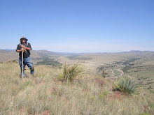
The country is west of Silver City, and probably allows an observer to "see" many different places in Apacheria. The visibility this day was probably ten or twenty miles. In the winter, and spring, some days, one could undoubtedly see, from where I took the photo, 50 miles straight line. Imagine the non-polluted air in the early 1800s. Only fires, and dust storms would have been pollutant sources. No factories; no modern farming, tilling of the land; no smog; no wood being burned by hundreds and thousands of folks; no factory pollution oozing up from Mexico.
In fact, I could see, without the use of binoculars, the shiny glint of vehicles moving along the highway, probably 6 - 8 miles out from where I gazed. Looking at the terrain between me and the highway, I'd guess I'd have under observation for several hours, any people on horse back, riding up to search for me ... one man ... with one rifle, serving as a sentinel, or a "stay behind," meant to snipe at Spanish, Mexicans, or Americans searching for my Apache raiding party.
But that distant look doesn't by any stretch, convey the utter rugged land that I'd have to negotiate as an Apache, fleeing after taking half a dozen shots at cavalrymen climbing the hills, to find me. Once Apache scouts worked for the Americans, then they were able to follow fleeing Apaches far better than the Americans. THEY would have been out ahead of a cavalry column, if it were an organized campaign. Otherwise, those Americans might not have had Apache scouts.
Americans weren't able to track Apaches as well, or as quickly.
From where the first photo with this blog was taken, I would merely have to walk a 100 yards or so, adjust my viewing position, and I'd see the vast Mogollon Mountains to the east, and streaming off to the north-northwest. The large mesa in the distance on the photo of the Mogollons is Sacaton Mesa. It's a large mesa, running 10 or so miles long and sometimes that wide. At the tail end of the Mogollons would be Glenwood, NM. That would have allowed escaping Apaches the choice of dodging into the "Diablos Mountains;" or the Mogollons; or head farther north, then drop down and cross the San Francisco River, and go up onto the mesas that are EASTERN Arizona.
Forty or fifty miles wests of there, would be the Ft. Apache Reservation, and, south of there,
San Carlos Apache Reservation. But the Apaches would have traveled along the ridge tops, and been able to cut down their travel time, for sure.
Labels: Burro Mountains; San Francisco River; Glenwood, NM; Ft. Apache, Reservation; San Carlos Apache Reservation; Snipers; Lookouts.
posted by skyminder at
9:42 PM
![]()

0 Comments:
Post a Comment
Subscribe to Post Comments [Atom]
<< Home