Upcoming Article


Currently, I'm working on several articles that will cover Hidalgo County, NM, & Apache history.
There's plenty to cover. The Southwest corner of New Mexico, which could be defined as all the land between the Gila River, where it bends southEAST, towards Duncan, AZ, and Virden, NM, all the way east to a line WEST of NM 180 West, around Mule Creek, NM, and south, along that line, all the way into the Bootheel. The Bootheel connects with the Chihuahuan "line." The Chihuahuan Line is roughly near Douglas, AZ. It's in that vast area, traveling north from the Chihuahua-Sonora-NM-AZ lines, to I-10, that much Apache history was made.
For those interested, this would also cover a large chunk of SouthEASTERN Arizona.
That line would run from the Whetstone Mountains, & AZ-Sonora border, up to I-10, currently. Travel EAST along I-10 to the NM line, and then turn south, again, along the AZ-NM line, and you have SouthEASTERN Arizona's chunk of Apacheria that matters.
The proposed articles I'll cover for Hidalgo County, NM, will be:
1. The 1882 fire fight between Loco's Chihene N'de Apaches in the Peloncillos, just north of Doubtful Cañon, in and around Horseshoe Cañon;
2. The possible fire fight near Black Point Mountain, in the Guadalupe Gap/Cloverdale Cañon area, adjacent to Cloverdale, NM;
3. A trip into Skull Cañon, NM. Skull Cañon is the cañon NORTH of Skeleton Cañon, where Geronimo initially tried to surrender to General Crook, in March, 1886;
4. Possibly an article on the Butterfield Stage Station posts in this area: namely, Doubtful Cañon (Steins Peak) station; Soldier's Farewell, in Grant County; the Separ location that was used as a heliograph site as well as basic Army encampment from time to time, during the last four years of the hunt for the belligerent Apaches.
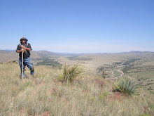
Here are a few photos:
1. Top Left: Horseshoe Cañon, Peloncillos (earlier referred to as the Stein's Range), about 2.5 miles NORTH of the Doubtful Cañon Butterfield Stage Station;
2. Top Right: Steeple Rock Mountain, taken from Canador Peak, which is east of Virden, NM;
3. Doubtful Cañon Butterfield Stage Station, one of the better preserved stations in the chain of stations;
4. Stein's Peak. A heliograph station was near there in 1886, after Gen. Nelson Miles took over the chase for Geronimo. If anyone has read any books about the hunt for Osama bin Laden, the "chase for Geronimo" would
have been the equivalent in 1885-1886.
posted by skyminder at
11:13 AM
![]()

4 Comments:
I have been to all these spots, and at each one I thanked God for men like Crook, Gatewood, Bourke, Rucker, Miles e.t.c.
During traveling such portions all these things portrays a very different kind of feel which is the reason traveling has its own certain impact bus tour east coast would be appealing for me big time and that is the reason maximum would be helpful for all the terms.
I live in Alamosa...is the area safe (being close the border)?
I live in Alamosa...is the area safe (being close the border)?
Post a Comment
Subscribe to Post Comments [Atom]
<< Home